Discovery
Colonisation
New Zealand Wars
The Maori
The Moriori
Biographies
New Zealand today
More topics

The New Zealand store - books, music ...

Documentary DVDs

View Maori culture videos
Site map
About me
Contact
New Zealand in France - more ...
..
Britannica iGuide


New Zealand in History


Back   
The eruption of Mount Tarawera
9th June 1886

During the night of 9th June 1886, after a series of constant quakes since midnight, a violent eruption occurred near the township of Rotorua. The top of nearby Mount Wahanga was completely blown off, producing a dense black cloud extending from Taheke to Paeroa, and which became a mass of thunder and lightening to continue incessantly the night long. Shortly after, nearby Mount Tarawera and its twin cone Ruawahia exploded into action, belching fire.

Lava and rocks were spewed to a height of around 10.000 feet. The rift caused by the eruption extended for an area approximately 12 miles in length. Hot rocks and mud from nearby Lake Rotomahana rained over an area of 6.000 square miles.

The famous Pink and White Terraces, listed as being among the wonders of the world, were destroyed. Before this disaster, the glistening water of the Terraces in the sunlight gave the breathtaking sight of a crystal sparkling staircase.

The explosions, lasting practically the whole night long, were heard and as far away as Auckland, Napier, Wellington and even Bleinhem, in the South Island. In some towns it was at first thought that a naval vessel had gone aground and was signaling for help. The nearby town of Wairoa, in the vicinity of the eruption, was covered ten feet thick with ashes, clay mud and stone. The only hint of disaster which the Wairoa residents had experienced in advance was a tidal wave which happened on Lake Tarawera two weeks beforehand, two feet high.

However, the local Māori had predicted the eruption. Flax had not flowered the season before, and the Māori predicted a dry summer accompanied by a large earthquake for the current year.

The Māori village of Te Wairoa, its Pa and whares were completely buried in the fallout of mud ash and rocks. Today Te Wairoa is known as The Buried Village.

153 Māori and Europeans perished in the Mount Tarawera eruption, that fateful night of 1886.
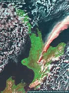
(click here for a map (25k) showing the position of Mount Tarawera)


Volcanism in New Zealand

The three major types of volcano in New Zealand are the cone volcano, the caldera volcano and the volcanic field.

Mount Ruapehu is a cone volcano, situated at the southern end of the Taupo Volcanic Zone - the most frequent active area. This zone covers an area extending from White Island to Ruapehu itself. Ruapehu is frequently active, and is one of the largest active volcanoes of New Zealand. Mount Ruapehu has erupted several times in the past : in 1861, 1895, 1903, 1945, 1969, 1971 and 1975. More recent eruptions occurred in 1995 and 1996.


Left : Satellite image of Mount Ruapehu in eruption, 17th June 1996. Thanks to the Manaaki Whenua Landcare Research website.


Volcanism in New Zealand covers the North Island areas from The Bay of Islands, Whangarei, Auckland, and White Island to Ruapehu and Egmont. The most active of these areas is the Taupo Volcanic Zone, covering the area from White Island to Taupo.

The cone type volcanoes produce successive eruptions near the vent, to form a huge cone, and the point of future eruptions is able to be predicted with reasonable accuracy.


The Taupo Volcanic Zone contains two of the most productive caldera volcanoes in the world, Taupo and Okataina. A caldera volcano is of the type generally so huge that the ground surface falls in, or collapses into the crater which it leaves behind. Lake Taupo fills an enormous hole created by a volcanic explosion in two parts, estimated at approximately 1.800 and 26.000 years ago, and which was seen in the skies as far away as China.

The most volcanic activity is situated in the North Island. The Tongariro National Park area and the Bay of Plenty coast have suffered the greatest volcanic activities in the past. Within the Tongariro National Park are situated Ruapehu, Ngauruhoe and Tongariro mountains.

Volcanoes in the North Island which are still active are Ruapehu, Tongariro, Ngauruhoe, White Island and Mount Tarawera. Mount Taranaki (also known as Mount Egmont - cone volcano) and Rangitoto are classed as dormant, although still considered eventual risk hazards.

Auckland is a volcanic field. In a volcanic field each eruption creates a small volcano, but which does not erupt again. However, in the volcanic field a further eruption may occur at a different place, and which is not able to be predicted until the eruption is practically on the point of taking place. Volcanic activity in the Auckland area commenced around 150.000 years ago. Rangitoto was the last major eruption, taking place just 600 years ago.

Although minor earthquakes are fairly common, the seismic activity in New Zealand is relatively moderate. The main seismic region of New Zealand extends over the totality of the North Island, apart from the Northland peninsula.

In the South Island, the seismic area extends to a lesser extent : an area lying between Banks Peninsula and Cape Foulwind, and also the areas of southern Westland, west Southland and west Otago.


Main source for research :
The New Zealand Official Year Book

Environmental Safety - Volcanoes and Climate Change
Cleaning Building Services Website - New York Office Services
Cleaning Services - NYC Cleaning
Green Cleaning - New York Cleaning Programs


top of page
 
Related Links
Tongariro National Park
New Zealand's volcanoes


 Please be aware that this website is a personal homepage. It would therefore be wise to cross check information which I have presented here. A list of many official New Zealand history sites may be found within my Links section.